Thingiverse
Mexico y El Norte by GlobeMaker
by Thingiverse
Last crawled date: 3 years ago
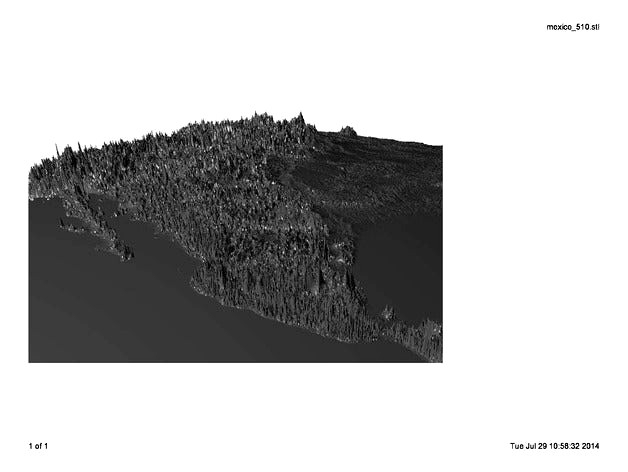
Citlaltépetl can be seen in this 3D model file. This .stl file has 25 x exaggeration of Mexico, and the Western USA. 2 mile resolution. 3.6 million triangles. The ETOPO2 database was used. This is one tile of 32 tiles of Earth.
The second photo includes a mountain that is 18,000 feet tall: Citlaltépetl . Past that is Yucatan.
The third photo looks South across Colorado, Texas, and Eastern Mexico.
The second photo includes a mountain that is 18,000 feet tall: Citlaltépetl . Past that is Yucatan.
The third photo looks South across Colorado, Texas, and Eastern Mexico.
Similar models
3dwarehouse
free

PARQUE MORELOS Citlaltépetl 9, La Paz, 72160
...az, 72160
3dwarehouse
citlaltépetl 9, la paz, 72160 heroica puebla de zaragoza, pue, méxico #citlaltépetl_9 #la_paz #méxico #pue
3dwarehouse
free

Citlaltépetl 2, Infonavit 12 de Mayo de 1918
...avit 12 de mayo de 1918, 72410 heroica puebla de zaragoza, pue, méxico #citlaltépetl_2 #infonavit_12_de_mayo_de_1918 #méxico #pue
3dwarehouse
free

Citlaltépetl 2, Infonavit 12 de Mayo de 1918
...8, heroica puebla de zaragoza, pue, méxico #citlaltépetl_2 #heroica_puebla_de_zaragoza #infonavit_12_de_mayo_de_1918 #méxico #pue
3dwarehouse
free

World Cup Visualization- Mexico vs South Africa
... google earth the photos of the players will appear on the field #africa #mexico #soccer #soccer_stadium #south_africa #world_cup
3dwarehouse
free

a mexico repo
...a mexico repo
3dwarehouse
a collaboration of classic tile and brick but with a modern twist
thingiverse
free

Stand for Snapfish 8x8 Photo Tile
...stand for snapfish 8x8 photo tile
thingiverse
tweaked the ipad stand to fit 8x8 photo tile from snapfish.
3dwarehouse
free

tile
...tile
3dwarehouse
large tile with inlay for photo or stone #building_component #do_as_you_will
3dwarehouse
free

Horacio - original Talavera tiles from Mexico
... for a shipping price. due to the manual nature of decor making, tile dimensions can vary to around 10% of their base dimensions.
3dwarehouse
free

Pablo - original Talavera tiles from Mexico
... for a shipping price. due to the manual nature of decor making, tile dimensions can vary to around 10% of their base dimensions.
3dwarehouse
free

Armando - Original Talavera Ceramic Tiles from Mexico
... for a shipping price. due to the manual nature of decor making, tile dimensions can vary to around 10% of their base dimensions.
Globemaker
thingiverse
free

Hawaii Region with Seafloor by GlobeMaker
...port explains how the satellites measured the seafloor depths by observing the changes in the height of the water due to gravity.
thingiverse
free

Global Warming Globe by GlobeMaker
...as 6 megabytes of data for 120,000 triangles. the amazon basin is under water, the mississippi valley is submerged. and worse...
thingiverse
free

Land Globe 200x in 500,000 Facets by GlobeMaker
... data were derived from the national geophysical data center (ngdc) etopo2 global 2' elevations data set from september 2001.
thingiverse
free

Moon Globe 5x by GlobeMaker
...team (lunar altimeter team). your data format is easy to use:http://l2db.selene.darts.isas.jaxa.jp/help/en/lalt_format_en_v01.pdf
thingiverse
free

Northeast Africa and Italy 25x by GlobeMaker
...rd photograph shows nigeria and the niger river. the sahara desert is seen to contain vast smooth areas, that must be sand dunes.
thingiverse
free

Mercury Globe 10x by GlobeMaker
...ion = "this data product is a shape map (radius)
of mercury at a resolution of 21.293 km/pix by 21.293 km/pix,
thingiverse
free

Santa Cruz Mountain Model, California by GlobeMaker
... pointing into the bottom left is the san lorenzo river valley with boulder creek.
the gray image is the quad from a lower angle.
thingiverse
free

Mercury Globe 5x in 516,000 Facets by GlobeMaker
...m
producer_full_name = "david e. smith"
producer_institution_name = "nasa/goddard space flight center"
thingiverse
free

Moon 10x Rev 2 by GlobeMaker
...team (lunar altimeter team). your data format is easy to use:http://l2db.selene.darts.isas.jaxa.jp/help/en/lalt_format_en_v01.pdf
Norte
turbosquid
$15

Nort Sea
...urbosquid
royalty free 3d model nort sea for download as prj on turbosquid: 3d models for games, architecture, videos. (1595916)
3ddd
$1

Odeon Light Norte
...odeon light norte
3ddd
odeon light
люстра и две бра odeon light norte
archive3d
free

Sofa 3D Model
...sofa 3d model archive3d sofa couch divan sofa norte n211016 - 3d model (*.gsm+*.3ds) for interior 3d...
3d_export
$13

luno
...nort of france coast. was modeled for 2accidentes marítmos" serie in youtube. rendering vray 3.0. formats: fbx, mb, obj, mtl
3d_export
$20

sinking bell tower
...continues to spark the curiosities of people visiting ilocos norte a northern province of the philippines.<br>its tale traces a...
3d_sky
free

Odeon Light Norte
...odeon light norte
3dsky
odeon light
chandelier and sconces two odeon light norte
thingiverse
free

Llavero Norte by ANTONIOTAO
...llavero norte by antoniotao
thingiverse
norte con taladro en la punta para utilizar como llavero
3d_sky
free

sofa Norte
...sofa norte
3dsky
length of 2140 mm. depth 870 mm
thingiverse
free

KIT Campus Nort by germaningenieur
...kit campus nort by germaningenieur
thingiverse
kit karlsruhe 3d zeichnung
3dbaza
$4

Norte Armchair (124661)
...t is recommended to install a version of at least 1.5, since the glossiness of the materials is adjusted taking into account pbr.
Mexico
turbosquid
$100

Mexico
... available on turbo squid, the world's leading provider of digital 3d models for visualization, films, television, and games.
3d_export
$5

eagle mexico
...eagle mexico
3dexport
tlatelolco eagle<br>for those who remember their trips to mexico, more than memorable
turbosquid
$70

Mexico Map
...ty free 3d model mexico map for download as 3ds, max, and obj on turbosquid: 3d models for games, architecture, videos. (1299218)
turbosquid
$49

New Mexico
... available on turbo squid, the world's leading provider of digital 3d models for visualization, films, television, and games.
turbosquid
$29

Soccerball Mexico
... available on turbo squid, the world's leading provider of digital 3d models for visualization, films, television, and games.
turbosquid
$15

New Mexico
... available on turbo squid, the world's leading provider of digital 3d models for visualization, films, television, and games.
turbosquid
$15

MEXICO-chair
... available on turbo squid, the world's leading provider of digital 3d models for visualization, films, television, and games.
turbosquid
$4

New-Mexico
... available on turbo squid, the world's leading provider of digital 3d models for visualization, films, television, and games.
cg_studio
$60

Mexico Map3d model
...map3d model
cgstudio
.3ds .max .obj .wrl - mexico map 3d model, royalty free license available, instant download after purchase.
turbosquid
$9

Mexico low poly
...lty free 3d model mexico low poly for download as max and obj on turbosquid: 3d models for games, architecture, videos. (1169260)
El
3ddd
$1

El torrent
...el torrent
3ddd
el torrent
фирма: el torrent il.luminacio-el torrent general catalogue. be 497
3ddd
$1

El Casco
...
el casco , настольные принадлежности
набор настольных принадлежностей компании el casco
turbosquid
$25

El Rey
...
turbosquid
royalty free 3d model el rey for download as max on turbosquid: 3d models for games, architecture, videos. (1261097)
turbosquid
$35

el.3ds
... available on turbo squid, the world's leading provider of digital 3d models for visualization, films, television, and games.
turbosquid
$20

El capitan.max
... available on turbo squid, the world's leading provider of digital 3d models for visualization, films, television, and games.
turbosquid
$20

El capitan.max
... available on turbo squid, the world's leading provider of digital 3d models for visualization, films, television, and games.
turbosquid
free

ELE VILLA
... available on turbo squid, the world's leading provider of digital 3d models for visualization, films, television, and games.
3d_export
$5

El Primo Matreshka
...el primo matreshka
3dexport
3d model el primo from brawl stars. style - toy matreshka. vertices: 4584 faces: 4762
3d_export
$15

El camino 3D Model
...el
3dexport
el camino 69 chevrolet automobile car pickup detailed custom high poly truck
el camino 3d model buncic 58908 3dexport
turbosquid
$50

3D EL Guitar
... available on turbo squid, the world's leading provider of digital 3d models for visualization, films, television, and games.
Y
turbosquid
$1

Tetera y Galletas y Caf
... available on turbo squid, the world's leading provider of digital 3d models for visualization, films, television, and games.
3ddd
$1

Смеситель Y-CON
...смеситель y-con
3ddd
смеситель , y-con
смеситель y-con
3ddd
$1

Y-Chair
...y-chair
3ddd
tom dixon
y-chair designed by tom dixon,
3ds max + obj, corona
3ddd
$1

Y Chair compilation
....net/products/us/y-chair-sled-base
y chair swivel basehttp://www.tomdixon.net/products/us/y-chair-swivel-base
turbosquid
$190

Y-8
...y-8
turbosquid
royalty free 3d model y-8 for download as max on turbosquid: 3d models for games, architecture, videos. (1658891)
turbosquid
$7

Bench Y
...turbosquid
royalty free 3d model bench y for download as obj on turbosquid: 3d models for games, architecture, videos. (1488746)
turbosquid
$15

bonePile Y
...oyalty free 3d model bonepile y for download as blend and obj on turbosquid: 3d models for games, architecture, videos. (1546374)
turbosquid
$7

Y for Yarn
...d
royalty free 3d model y for yarn model for download as max on turbosquid: 3d models for games, architecture, videos. (1699732)
turbosquid
$2

FONT Y
...quid
royalty free 3d model font y for download as ma and obj on turbosquid: 3d models for games, architecture, videos. (1549457)
3ddd
$1

WOOD-y
...wood-y
3ddd
wooden guy